AfReSlide
AfReSlide
Landslides in Equatorial Africa: Identifying culturally, technically and economically feasible resilience strategies
AfReSlide (2013-2018) is a scientific project funded by the Belgian Federal Scientific Policy (Belspo), as part of the Belgian Research Action through Interdisciplinary Networks (BRAIN-be).
All the abstracts of our publications are online! Check them out here!
Find our Policy Briefs here!
Find the posters on 'living with landslides' here!
**SHORT UPDATE** D4D Digital for Development iChoose award – Make your vote count
The D4D prize aims at rewarding outstanding initiatives that use new technologies as a lever for development towards achieving the UN Sustainable Development Goals. Six projects are presented through short video’s. Before May 11, the public is invited to score each video’s from 1 to 5 (highest score): http://prized4d.africamuseum.be/en/ichoose. The video with the highest score will get awarded the iChoose prize of 5000 €. By voting, you not only support your project of choice, but also the ambition to incorporate digitalization for development in the program of the Belgian Development Cooperation. In case you would like some inspiration before casting your vote, we are happy to present you the Geo-observer Network:
The Rwenzori Mountains, a remote, 5,000 m high mountain in central Africa (Uganda) is a region often affected by landslides, floods and other natural hazards. Studying these hazards to better understand the risks they produce is key to achieving the Sustainable Development Goals in this region. The department of Geography of the VUB, the department of Earth & Environmental Sciences of the KU Leuven, and the Natural Hazards Service of the Royal Museum for Central Africa have therefore partnered with the Mountains of the Moon University (Uganda). With the support of VLIR-UOS, a network of citizen scientists was established, reporting on new hazards and their impact in their environment: http://prized4d.africamuseum.be/en/geo_observer_network. Over 20 local farmers are trained to use a smartphone with a versatile application to provide structured data through the mobile network. Combined with other awareness raising tools and research efforts, the geo-observer data collection enables to develop evidence-based environmental planning and disaster risk reduction. This project is an example of how technologies can help to develop research with and by the local communities, especially in remote, disaster-prone environments. The video presented here is produced by our Ugandan colleagues and illustrates the work of the geo-observers across these Mountains of the Moon.
Thank you for your vote!
Recent News (Februari 2018):
Succesfull week of dissemination in Uganda!
A conference was organized in Kampala, at national level. It was attended by the minister of disasters and refugees, several members of the Office of the Prime Minister, representatives of civil society and NGO's as well as researchers from Uganda, Belgium and Cameroon.
Several workshops were held at local levels, including one at Mountains of the Moon University and one in Bundibugyo and one in Kasese. These workshops were attended by district authorities, local researchers and students, as well as community members and geo-observers.
During the conference and the workshops, more than 300 policy briefs and 400 posters on 'living with landslides' were distributed. These posters were translated in Lukonzo, Lubwissi and Lutoro, the three main languages in the Ruwenzori region.
Previous News (August 2017):
NEW : The Newsletter of September 2017 is published! Check it out here!
A (last?) fieldwork is ongoing in the Bamboutos in Cameroon! Midas Baert, masterstudent at the University of Leuven, is doing research for his masterthesis, investigating which factors influence whether farmers want to relocate in the Bamboutos. This research fits into the socio-economic analysis of DRR strategies at household level. This is one of the major topics of the research of Kewan Mertens. Find out more about this research here!
The regional landslide susceptibility map for the Rwenzori mountains in Cameroon might well be available soon. Out main researcher on landslides susceptibility, Lies Jacobs, is currently running the last robustness checks. We are excited about the results! Keep an eye on the progress on Lies' research here!
We are launching an ART COMPETITION! To sensitize local stakeholders about individual measures that can be taken against landslides in the Rwenzori region, a poster is being developed. The messages will be conveyed with drawings that are made by artist in the Rwenzori region. The competitions is currently ongoing. Do you have amazing drawing/designer skills, or do you know someone that could have these skills? Please feel free to contact Clovis or Jan for further information!
More publications are coming! Check them out here!
Stay updated on our work:
Check the different work packages
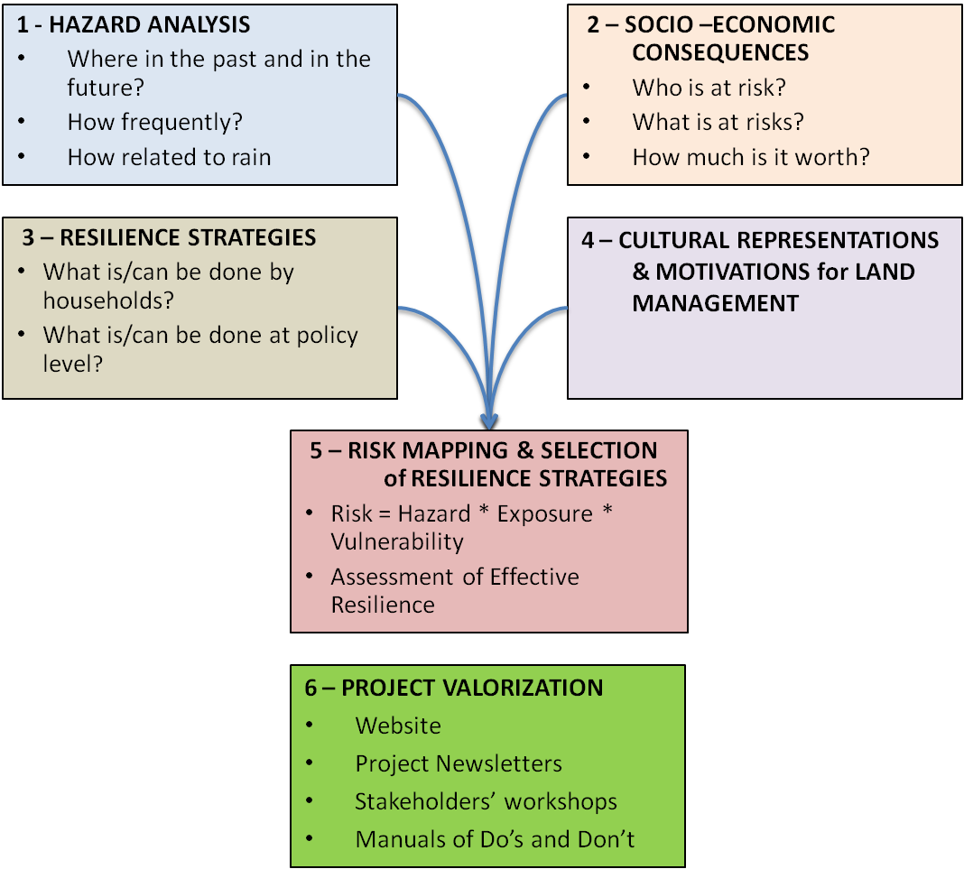
- Work Package 1 on hazard analysis
- Work Package 2 on socio-economic consequences
- Work Package 3 on resilience strategies
- Work Package 4 on cultural representations
- Work Package 5 on risk mapping
... and our newsletter:
- Newsletter AfReSlide Issue 1: June 2014
- Newsletter AfReSlide Issue 2: January 2015
- Newsletter AfReSlide Issue 3: June 2015
- Newsletter AfReSlide Issue 4: December 2015
- Newsletter AfReSlide Issue 5: June 2016
- Newsletter AfReSlide Issue 6: January 2017
- Newsletter AfReSlide Issue 7: September 2017
Subscribe to our newsletter HERE
Or send us an email on afreslide@vub.ac.be